
Scientific background
As part of the Swabian MOSES measurement campaign, scientists are specifically investigating local-scale thunderstorms associated with heavy rainfall and hail, and large-scale heat waves and their associated droughts. Although these two types of extremes are triggered at very different temporal and spatial scales, they share several common characteristics: They are often associated with similar large-scale synoptic flow patterns such as atmospheric blocking. This flow pattern is characterized by large-scale weather patterns that hardly change over a longer period of time, sometimes several weeks, and thus suppress the flow regime typical for the mid-latitudes (westerly wind drift). Affected regions can thus experience weather that differs significantly from the expected conditions for a longer period of time.
As a result, precipitation can be absent for weeks, and instead dry and warm air can reach the affected regions without interruption. Often, such heat waves are terminated by the widespread occurrence of severe thunderstorms. These thunderstorms have a high potential to bring particularly severe associated phenomena, such as extreme heavy rain and flash flooding, large hail, or convective strong wind gusts that can reach hurricane force. The frequency and intensity of both heat waves and severe thunderstorms have increased significantly in recent years due to climate change. In the study region in Baden-Württemberg, they represent the natural hazards with the most negative impacts: Thunderstorms cause the highest share of financial damage, heat waves claim the most lives.
With the highly industrialized Neckar valley and the open landscape of the Swabian Alb, the study area represents a unique landscape and settlement area that is ideally suited for the implementation of a combined and coordinated field experiment. The terrain has a large elevation gradient, the soil types change significantly over short distances, and the river basins are rather small. The study area is one of the regions with the highest exposure to severe thunderstorms in Germany, but is also frequently affected by severe heat waves, the effects of which vary due to spatial differences in terrain characteristics and vegetation.
The approach of MOSES to reproduce and analyze the event chains of hydro-meteorological extremes aims, on the one hand, to better understand the mechanisms and processes responsible for triggering and intensifying the events, and, on the other hand, to study in detail their impacts and interactions with all their facets.
Information on the measurement systems used at Swabian MOSES can be found here.
Aerosol particles
Aerosol particles
In addition to the influence of the heat and drought periods, which have also occurred frequently in Germany in recent years, on vegetation and entire ecosystems, such extreme events also affect the concentrations of trace gases and aerosol particles in the atmosphere. Therefore, it is also of great interest how heat, drought, soil moisture and meteorological parameters influence the spatial distribution, number concentration, composition and size distribution of aerosol particles (see aerosol measurement systems) and to what extent there are feedbacks to meteorological phenomena here.
The formation of ice particles in high range (convective) clouds such as thunderclouds influences the resulting precipitation and cloud development. Ice formation is triggered by ice nucleating aerosol particles (INPs), a very small subset of the total aerosol particles. During the measurement campaign, INPs are measured quasi-continuously near convective clouds. The INP concentrations will be correlated with other aerosol particle measurements and meteorological parameters to investigate the role of aerosol particles and INPs in the formation of particularly high-level convective clouds that can grow into especially severe thunderstorms.
Authors: Dr. Harald Saathoff, Dr. Ottmar Möhler, IMK-AAF
Soil moisture measurements
Soil moisture measurements
Soil moisture is a key control variable for the runoff of rainwater. If the soil is very moist or extremely dry, rainwater can no longer be absorbed by the soil and runs off over the earth's surface. This situation accelerates the risk of flooding. As an influential parameter for the water availability of vegetation, soil moisture thus provides information about the prevailing drought stress in plants during prolonged periods of drought. Therefore, a solid estimate of soil moisture in the large-scale area is crucial for early detection of impending weather extremes and their consequences.
The stationary sensors for determining soil moisture using cosmic neutron detectors have been already successfully used in research (TERENO) and agriculture. Within the framework of Swabian MOSES, the potential of the mobile cosmic neutron detector (Cosmic Ray Roving, see figure) for large-scale soil moisture monitoring is being further developed and evaluated. In addition, the integration of different soil moisture measurement technologies from continuous-time point scale (local soil moisture sensors) to large-scale snapshots (e.g., with remote sensing data) will be advanced towards purpose-oriented soil moisture products.
Data collected during the measurement campaign will be used to map the spatial distribution of soil moisture in the region and track its temporal variation over the months. This should make it possible to learn more about extreme hydrological events, such as the evolution and impact of heat waves, and thereby improve mesoscale hydrological models.
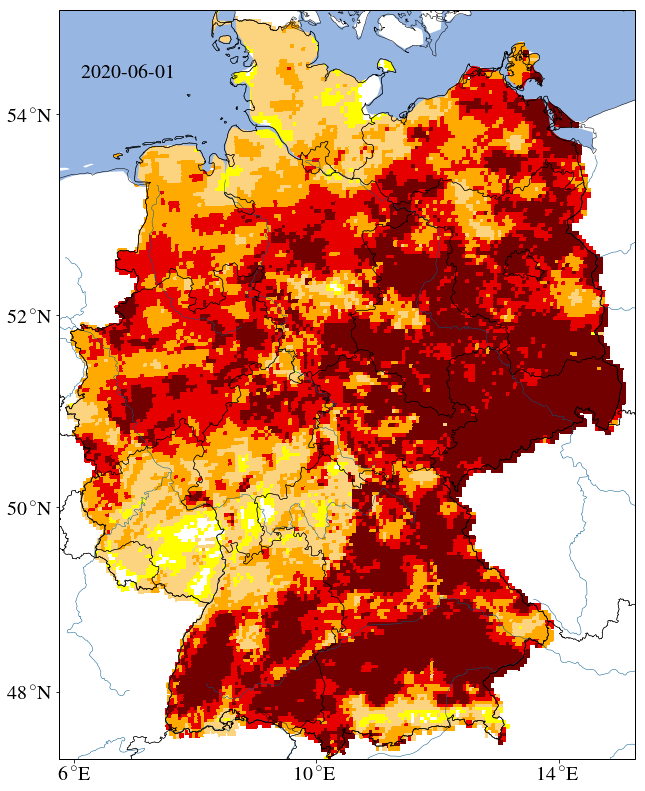
One such model is the mHM of the UFZ which is the basis of the drought monitor of Germany (see figure). This monitor provides maps of the daily drought status of the total soil and topsoil as well as the plant-available water in the soil of Germany.
Authors: Mandy Kasner, Prof. Dr. Peter Dietrich, UFZ
Additional information on Cosmic Ray Neutron Sensing & Roving and its use in other projects: Homepage
Thunderstorm frequency
Thunderstorm frequency

One of the most challenging tasks for numerical weather prediction models is the prediction of high-level convection (thunderstorms). In particular, why, where, and under what environmental conditions (moist) convection is triggered in the atmosphere and whether the transition to high-level convection occurs is not yet fully understood.
The onset of convection requires an unstable stratified troposphere (lowest 10-15 kilometers of the atmosphere), a sufficient moisture supply, and a triggering mechanism that helps overcome convective inhibition in the deep tropospheric layers. Processes at the Earth's surface and in the atmospheric boundary layer (about the lowest kilometer of the troposphere) have a particular influence on the triggering of convection, especially when the flow in the middle and higher tropospheric layers is not as strong.
The triggering of convection by such boundary layer processes is often linked to spatial inhomogeneities of land use and/or soil water content. In addition, so-called convergence zones of different origin (e.g., due to slope or mountain-valley wind systems) are important phenomena. In such convergence zones, moisture-enriched air in the lower troposphere converges, resulting in strong upwelling motions as a compensation in the area of the convergence zone.
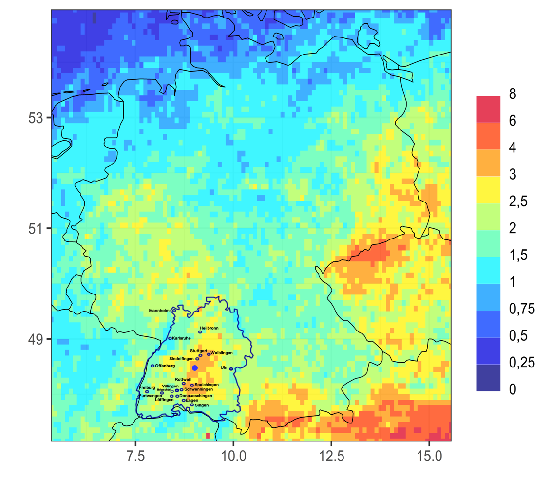
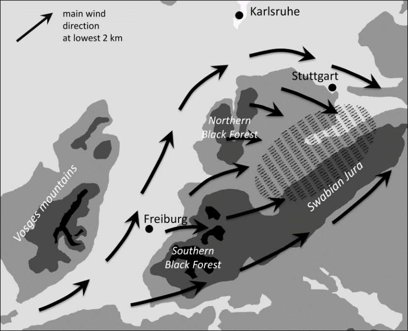
The Swabian MOSES study area in the Swabian Alb region is a hotspot for thunderstorms and hailstorms (see figure). Kunz and Puskeiler (2010) hypothesized that a pronounced convergence zone is created by flowing around the low mountain range, especially with weak to moderate southwesterly flow downstream of the Black Forest (see sketch). When it hits the Black Forest, the flow splits into two parts: one that flows around the northern Black Forest after channeling in the Rhine valley, and one that flows around the southern flank. Downstream of the Black Forest and upstream of the Swabian Alb, the two branches meet again and cause a convergence of the flow in the lower troposphere, which favors the onset or further intensification of (high-level) convection. This could be an explanation for the increased number of thunderstorms in the area of the Swabian Alb and the adjacent Neckar valley, which is also indicated by model simulations with the DWD 's COSMO model.
Within the framework of Swabian MOSES, convergence zones in the run-up to strong thunderstorms are to be detected. How the flow convergence develops during the course of the day as a function of the prevailing environmental conditions (i.e., flow velocity, direction, and stability) and how this is reflected in the development of thunderstorms will be investigated using wind measurements (research aircraft, balloon soundings, wind lidars, precipitation radar) and stability analyses(balloon soundings, microwave radiometer).
Authors: Prof. Dr. Michael Kunz, Jannik Wilhelm, IMK-TRO
Hail trajectories
Hail trajectories
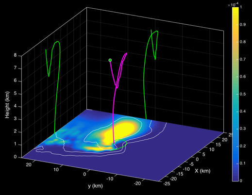
The vertical temperature and humidity profile and the convective energy associated with it are decisive in determining whether thunderstorm events can develop in principle, and provide indications of their possible intensity. The three-dimensional (3D) wind field, on the other hand, determines the organizational form of thunderstorms in the form of single cells, multicell complexes, or supercells (strongest thunderstorms with rotating updrafts). In the upwind region of a thunderstorm cloud, the flow field also determines the strength of precipitation in the form of rain or hail. Operationally, vertical profiles are measured with radiosondes only twice a day and at only nine stations throughout Germany. Within the framework of Swabian MOSES, these measurements are carried out on special Intensive Observation Periods (IOPs) on the one hand with high temporal resolution with the aim of being able to better estimate the temporal development of the convection energy. On the other hand, measurements are made directly in the upwind region of a thunderstorm cell in order to analyze and better understand the unknown trajectories of the precipitation particles as a function of the prevailing ambient conditions.
Newly developed swarm probes from the Sparv company are used here, which are much smaller (the size of a yogurt cup) and lighter (12 grams) than conventional radiosondes. The probes ascend to a user-defined altitude and then follow the flow in the thundercloud on so-called Lagrangian orbits, from which hail trajectories can then be derived (see figure; graphic by Dennis & Kumjian, 2017). In a mobile deployment, the probes are launched in the immediate vicinity to a thundercloud, providing information from temperature, humidity, pressure, and the 3D wind field directly from the updraft-ideally from hail-producing thunderstorms (Markowski et al., 2018). Up to 17 balloon-borne probes can be launched and tracked simultaneously or sequentially.
The temporally / spatially high-resolution measurements of the swarm probes ideally complement the vertical profiles of wind, temperature, and humidity measured at other stations (radiosondes, microwave radiometers, wind lidar) by providing information on the temporal variability of environmental conditions that has not been observed in this level of detail before. In the case of hail events, the measured trajectories are related to the observed hail spectra from the hail sensors (HailSens) and various hail reports (DWD WarnWetter app, database of the European Severe Weather Database, ESWD) and compare them with model results.
Supercells with rotating updrafts mentioned at the beginning, which can produce very large hailstones, are also sources of low-frequency pressure fluctuations according to current research. These are detectable with ground-based infrasound microphones in the frequency range from a few to about 10 Hertz. Since there are very few observations of infrasound from thunderstorm cells to date where these measurements have been made in conjunction with comprehensive sensor technology to determine flow conditions in the cloud, as is available in the Swabian MOSES campaign, an infrasound sensor will also be operated throughout the campaign period.
Authors: Prof. Dr. Michael Kunz, IMK-TRO & Dr. Frank Hase, IMK-ASF